This is AI generated summarization, which may have errors. For context, always refer to the full article.
If the low pressure area becomes a tropical depression, it would be given the local name Verbena
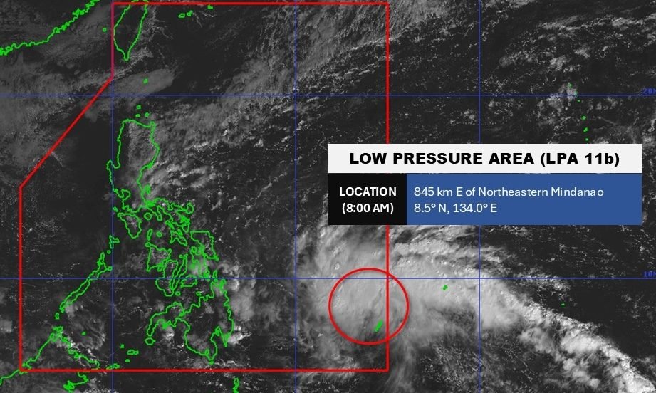
MANILA, Philippines – A low pressure area (LPA) that entered the Philippine Area of Responsibility (PAR) on Sunday morning, November 23, has a high chance of developing into a tropical depression within 24 hours.
As of 8 am on Sunday, the LPA was located 845 kilometers east of northeastern Mindanao, said the Philippine Atmospheric, Geophysical, and Astronomical Services Administration (PAGASA) in a Facebook post.
If the LPA becomes a tropical depression, it would be given the local name Verbena.
Northern Mindanao, Caraga, the Davao Region, Eastern Visayas, and Bohol may already see scattered rain and thunderstorms from the trough or extension of the LPA on Sunday, while significant rain is expected to begin by Monday, November 24.
At 11 am on Sunday, PAGASA issued a three-day rainfall outlook for the LPA, which will first affect areas located on the eastern side of the country. Floods and landslides are likely.
Sunday noon, November 23, to Monday noon, November 24
- Heavy to intense rain (100-200 millimeters): Eastern Samar
- Moderate to heavy rain (50-100 mm): Albay, Sorsogon, Northern Samar, Samar, Leyte, Biliran, Southern Leyte, Surigao del Norte, Dinagat Islands
Monday noon, November 24, to Tuesday noon, November 25
- Heavy to intense rain (100-200 mm): Southern Leyte, Leyte, Cebu, Bohol, Negros Occidental, Capiz, Dinagat Islands
- Moderate to heavy rain (50-100 mm): Occidental Mindoro, Oriental Mindoro, Romblon, Northern Samar, Samar, Eastern Samar, Biliran, Albay, Sorsogon, Negros Oriental, Siquijor, Antique, Aklan, Iloilo, Guimaras, Masbate, Surigao del Norte, Surigao del Sur, Agusan del Norte, Misamis Oriental, Camiguin, Bukidnon, Agusan del Sur
Tuesday noon, November 25, to Wednesday noon, November 26
- Heavy to intense rain (100-200 mm): Aklan, Palawan, Antique, Occidental Mindoro, Oriental Mindoro
- Moderate to heavy rain (50-100 mm): Quirino, Rizal, Batangas, Laguna, Camarines Sur, Camarines Norte, Catanduanes, Albay, Sorsogon, Masbate, Marinduque, Romblon, Capiz, Iloilo, Guimaras, Negros Occidental, Negros Oriental, Cebu, Bohol, Samar, Northern Samar, Eastern Samar, Biliran, Leyte, Southern Leyte
In addition, PAGASA is monitoring the effects of the shear line, or the point where cold air from the northeast monsoon or amihan converges with the easterlies or warm winds from the Pacific Ocean.
Here is the latest rainfall outlook for the shear line, also issued at 11 am on Sunday:
Sunday noon, November 23, to Monday noon, November 24
- Moderate to heavy rain (50-100 mm): Cagayan, Isabela
Monday noon, November 24, to Tuesday noon, November 25
- Moderate to heavy rain (50-100 mm): Cagayan, Isabela, Apayao, Kalinga, Aurora, Quezon
Tuesday noon, November 25, to Wednesday noon, November 26
- Heavy to intense rain (100-200 mm): Isabela, Aurora, Quezon
- Moderate to heavy rain (50-100 mm): Cagayan, Apayao, Kalinga, Mountain Province, Ifugao, Bulacan
The weather bureau also said earlier in its 4 am forecast that the shear line may bring scattered rain and isolated thunderstorms to Apayao and Quirino on Sunday.
The rest of the Cordillera Administrative Region and the rest of Cagayan Valley are affected by the northeast monsoon itself, which can cause moderate to at times heavy rain during the day.
The northeast monsoon is affecting the Ilocos Region on Sunday, too, but only isolated light rain is expected.
PAGASA added that the easterlies may trigger scattered rain and thunderstorms in Aurora, Quezon, and Camarines Norte, as well as isolated rain showers or thunderstorms in the rest of Central Luzon, rest of Southern Luzon, Central Visayas, and Western Visayas on Sunday.
The rest of Mindanao will only have isolated rain showers or thunderstorms due to the intertropical convergence zone or ITCZ, a belt near the equator where the trade winds of the Northern Hemisphere and Southern Hemisphere meet. – Rappler.com


